We get a lot of questions about the Chicago Pedway system our private tours of downtown. So here are some more in-depth responses.
We research stories from Chicago history, architecture and culture like this while developing our live virtual tours, in-person private tours, and custom content for corporate events. You can join us to experience Chicago’s stories in-person or online. We can also create custom tours and original content about this Chicago topic and countless others.
How do you know you’re in the Pedway?

You know you’re in it when you see the symbol to the right. The mostly-underground system of passages connects buildings, train stations, and parking lots around the Loop. One finds government offices, food courts, and most importantly during wintertime – warmth. As part of downtown infrastructure, these tunnels eases foot traffic on street level. It also provides a quicker route, since pretty much everyone down there is in a hurry like you. Plus, you don’t have to wait at any stop lights!
Where does the Pedway go?
Built in Chicago for Chicagoans, this system is still a bit of a conundrum for local government. Yes, the city has an official map of it, but they do not have any specific department that manages the Chicago Pedway. Each section of the tunnels was built and is managed by the building attached. For example, when you walk by the passageway around Macy’s they are responsible for the visual look and security here.
Why don’t people use the Pedway all the time if it’s so great?
It can be fascinating to explore, and a good photographer can find interesting angles, but the Pedway is not nearly as visually exciting as the street-level above. For this reason, we downtown workers tend to reserve it for bad weather or when we’re in a hurry.
Are there plans to extend it?
Well, they recently have in fact. The completion of Aqua Tower in 2009 extended the Pedway to reach its parking garage and the would include the newly opened Radison Blu Hotel. If any new buildings arise in the vicinity of the system, a developer would likely want to connect a new residential or commercial building with the pre-existing infrastructure. This piecemeal add-on method is how the Pedway has grown to be the confusing thing it is now. There never was any master plan.
How do I get my hands on a good map of the Pedway?
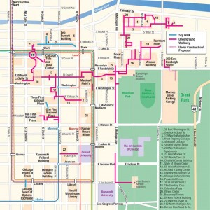
Good question here. Mark Spiegl’s Pedway map, pictured here, lays out the primary paths quite clearly. Its simplicity is less daunting than the City of Chicago‘s map, which is cluttered with details.
We are working on our own Chicago Detours map of the Pedway, and we are determined to keep it user friendly. This project has grown into a much more complicated goal than imagined. So a question for you: How does one make an understandable map when the subject matter at hand is confusing? The northeast area of the Pedway, for example, goes from underground to ground level to above ground, and then at times its the outside ground level that’s changing rather than the grade of the Pedway route! That area of the city has multiple layers of parking, streets, and furthest underneath, wood pilings and abandoned freight tunnels. This question is pretty complicated so I don’t expect any easy answers! (Update: here’s our completed map!)
Why don’t more people know about the Pedway?
This is an interesting one and requires a long response. Look next month for a full blog post dedicated to this question.
– Amanda Scotese, Executive Director
ABOUT CHICAGO DETOURS
Chicago Detours is a boutique tour company passionate about connecting people to places and each other through the power of storytelling. We bring curious people to explore, learn and interact with Chicago’s history, architecture and culture through in-person private group tours, content production, and virtual tours.
